Zuiderzee

                 
Zuiderzee Ijsselmeer Markermeer Afsluitdijk VOC                  
Description
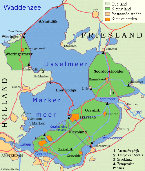
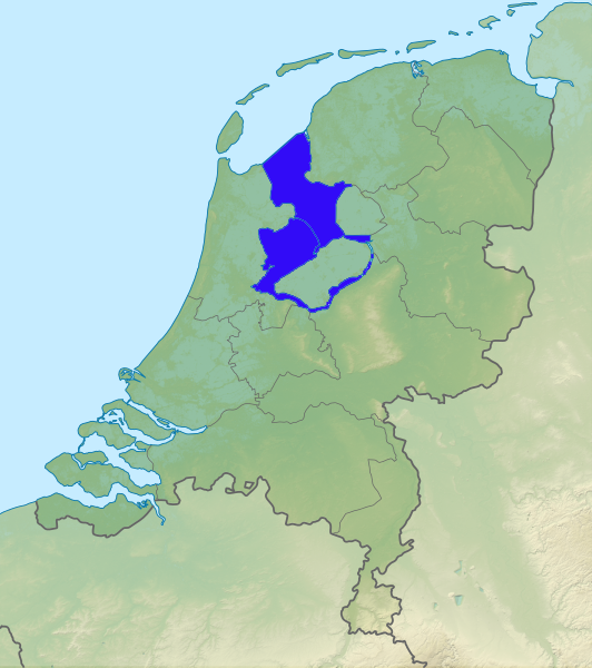
Le Zuiderzee  - littéralement :'Mer du Sud ' -   est un ancien golfe du centre-nord des Pays-Bas. Il est transformé en lac d'eau douce appelé IJsselmeer et en polders à la suite de l'exécution des travaux du Zuiderzee.
 
Situation - Région Pays GPS / Lat - Long Altitude  
Mer du Nord - Océan atlantique

Pays-Bs

52° 36' N - 05° 30' E m  
Type Longueur Largeur Hauteur Superficie Périmètre Profondeur Volume

Inclinaison
Pente

Poids

golfe

km

km m km2 km moyenne : m
maximale : m
km3  
Histoire

A historic story about the Zuiderzee

This is a remarkable story about the fight against the water. It is a piece of water which embodies both the pride and pain of the Netherlands. Until 1932, the Zuiderzee was an inland sea. Fun fact: before that time, we used to talk about Amsterdam aan Zee, Volendam aan Zee, and Marken aan Zee. Large flooding and disasters would ready the Dutch for the biggest battle they ever thought: the battle against the water.

Before 1916
Amsterdam, Marken, Volendam and Monnickendam are coastal towns on the Zuiderzee, which is about 6,000 square kilometers in surface. On the bank of the Zuiderzee, fishing and trade communities arise. This area is nowadays called the Old Harbors.

1916
Flooding disaster hits the Netherlands. On January 13 and 14, fate strikes. A storm surge raises the water level in the Zuiderzee, while excessive melt water in the main rivers of the Netherlands also ends up in the same Zuiderzee. The result is breaking of the levees in a dozen of places at the Zuiderzee. The death toll is limited, but fear has struck deep.

1918
The Zuiderzee-bill is passed. The results of the Flooding Disaster two years before have readied the Dutch: the sea has to be contained, no matter the consequences for fishermen and seamen.

1932
The Netherlands take on the battle with the water, particularly the turbulent sea. The Afsluitdijk between Den Oever (Noord-Holland) and Zurich (Friesland) is completed. The 32-kilometer sea wall spells the end of the Zuiderzee. The area below the Afsluitdijk is called the IJselmeer. The water is brackish, instead of salty. This has big consequences for the fishing community.

1940
A start is made with the draining and impoldering of the future twelfth province of the Netherlands: Flevoland. Before 1940, almost the entire area consists solely of water.

1953
This year is synonymous for ‘De Watersnoodramp’. A combination of a western storm and spring tide causes a disaster in the south of the Netherlands in the night January 31 to February 1. The Afsluitdijk passes its first major test. In the south of the Netherlands 1836 people die, 100,000 people lost their homes, and 200,000-hectare land is flooded, but in the area of the former Zuiderzee, damage is limited to a minimum.

1957
The construction of the levee to Marken. The island of Marken is turned into a peninsula, connected to the main land by the Zeedijk. Provisioning by ice sailors in winter is no longer necessary. The tight community of Marker becomes more accessible to outsiders.

1976
The Houtribdijk between Enkhuizen and Lelystad is finished. Marken and Volendam are no longer on the IJselmeer, but on the Markermeer. The intention is to gain more land in the Markermeer. Marken will lose its island status, and become part of a larger, depoldered area.

1986
The Netherlands officially get their twelfth province. Flevoland, to the west of Marken, has been entirely “gained“ on the water. An ingenious project of impoldering leads to 1,500 square kilometers of extra land in the Netherlands.

2003
It is officially decided that no more parts of the Markermeer will be drained. Marken will remain a peninsula.

Present
The area around the Gouwzee consists of the authentic villages of Marken, Volendam, and Monnickendam. Fishing is still big in this area, but tourism is also a large source of income. The ferry service of Volendam Marken Express makes a visit to the triangle around the Gouwzee a real experience.
Adresse web Mail Tél / Mobile  


Photos    
     
A proximité      
Musées, expositions Restaurants, Hôtels Parcs, promenades Divers


Comment y aller ?
           
           
  A voir


  A faire


Type Caractéristiques Evaluation


Histoire
 
Contact - Nom Téléphone / gsm mail web note
info        
réservation        
office        
Sites web